![](/images/other/stat-length.png)
![Tour Mountainbike Le Mans - Autour du Mans Nord - Photo](https://media.geolcdn.com/t/1900/400/ext.pjpeg?maxdim=2&url=https%3A%2F%2Fstatic1.geolcdn.com%2Fsiteimages%2Fupload%2Ffiles%2F1524743154velo.jpg)
Autour du Mans Nord
tracegps
Benutzer
![Länge](/images/other/stat-length.png)
Länge
45 km
![Maximale Höhe](https://static1.geolcdn.com/siteimages/upload/files/1508320355ic_sort_altitude_max_24dp.png)
Maximale Höhe
140 m
![Positive Höhendifferenz](https://static1.geolcdn.com/siteimages/upload/files/1508320355ic_sort_den_pos_24dp.png)
Positive Höhendifferenz
595 m
![Km-Effort](/images/other/stat-length.png)
Km-Effort
53 km
![Min. Höhe](https://static1.geolcdn.com/siteimages/upload/files/1508320355ic_sort_altitude_min_24dp.png)
Min. Höhe
44 m
![Negative Höhendifferenz](https://static1.geolcdn.com/siteimages/upload/files/1508320355ic_sort_den_neg_24dp.png)
Negative Höhendifferenz
580 m
![Boucle](https://static1.geolcdn.com/siteimages/upload/files/16400158638029165_repeat_loop_refresh_sync_direction_icon.png)
Boucle
Nein
Erstellungsdatum :
2014-12-10 00:00:00.0
Letzte Änderung :
2014-12-10 00:00:00.0
![Mountainbike](https://static1.geolcdn.com/sitytour/trail-icons/202.png)
3h00
Schwierigkeit : Schwierig
![Scannen Sie diesen QR-Code, um die Tour in der SityTrail-Anwendung zu öffnen](https://capi.geolives.com/qq0zvz2zws4bq2lad0pu/sitytour/trails/129848/qr.png?size=200)
Kostenlosegpshiking-Anwendung
Über SityTrail
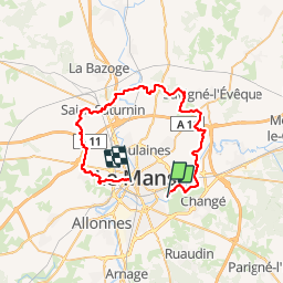
Tour Mountainbike von 45 km verfügbar auf Pays de la Loire, Sarthe, Le Mans. Diese Tour wird von tracegps vorgeschlagen.
Beschreibung
Boucle autour du Mans Nord. Départ depuis l'Abbaye de l'Epau. Passage à Yvré l'Evêque, puis près de Neuville sur Sarthe, Saint Saturnin, La Milesse, La Chapelle Saint Aubin, Rouillon. Retour jusqu'à la Place de la République
Ort
Land:
France
Region :
Pays de la Loire
Abteilung/Provinz :
Sarthe
Kommune :
Le Mans
Standort:
Unknown
Gehen Sie:(Dec)
Gehen Sie:(UTM)
294129 ; 5318990 (31T) N.
Kommentare
Touren in der Umgebung
![Tour Mountainbike Changé - Boucle Le Mans - Changé - Brettes - Parigné - Challes 53 km - Photo](https://media.geolcdn.com/t/375/260/ext.jpg?maxdim=2&url=https%3A%2F%2Fservices.sitytrail.com%2FGeolivesWS%2FDownloadMedia.ashx%3FTrailID%3D172382%26Media%3D13727_1.jpg)
![Mountainbike Mountainbike](https://static1.geolcdn.com/sitytour/trail-icons/202.png)
Boucle Le Mans - Changé - Brettes - Parigné - Challes 53 km
Mountainbike
Medium
(2)
Changé,
Pays de la Loire,
Sarthe,
France
![](/images/other/stat-length.png)
53 km | 60 km-effort
2h 30min
![](https://static1.geolcdn.com/siteimages/upload/files/16400158638029165_repeat_loop_refresh_sync_direction_icon.png)
Nein
![Tour Wandern Le Mans - Le Mans, randonnée autour et dans la ville - Photo](https://media.geolcdn.com/t/375/260/ext.jpg?maxdim=2&url=https%3A%2F%2Fmedia.geolcdn.com%2Ff%2Fbec9cef1-0536-4c4e-939a-116e56206659.jpg)
![Wandern Wandern](https://static1.geolcdn.com/sitytour/trail-icons/101.png)
Le Mans, randonnée autour et dans la ville
Wandern
Einfach
Le Mans,
Pays de la Loire,
Sarthe,
France
![](/images/other/stat-length.png)
23 km | 26 km-effort
10h 57min
![](https://static1.geolcdn.com/siteimages/upload/files/16400158638029165_repeat_loop_refresh_sync_direction_icon.png)
Ja
![Tour Wandern Le Mans - Arche de la nature - Photo](https://media.geolcdn.com/t/375/260/ext.jpg?maxdim=2&url=https%3A%2F%2Fmedia.geolcdn.com%2Ff%2Fe44f39e5-6695-45d2-ba25-89283625b186.jpg)
![Wandern Wandern](https://static1.geolcdn.com/sitytour/trail-icons/101.png)
Arche de la nature
Wandern
Einfach
Le Mans,
Pays de la Loire,
Sarthe,
France
![](/images/other/stat-length.png)
5,4 km | 6 km-effort
45min
![](https://static1.geolcdn.com/siteimages/upload/files/16400158638029165_repeat_loop_refresh_sync_direction_icon.png)
Ja
![Tour Mountainbike Coulaines - 34 km coulaines - Photo](https://media.geolcdn.com/t/375/260/ext.jpg?maxdim=2&url=https%3A%2F%2Fstatic1.geolcdn.com%2Fsiteimages%2Fupload%2Ffiles%2F1524743154velo.jpg)
![Mountainbike Mountainbike](https://static1.geolcdn.com/sitytour/trail-icons/202.png)
34 km coulaines
Mountainbike
Medium
(1)
Coulaines,
Pays de la Loire,
Sarthe,
France
![](/images/other/stat-length.png)
34 km | 40 km-effort
Unbekannt
![](https://static1.geolcdn.com/siteimages/upload/files/16400158638029165_repeat_loop_refresh_sync_direction_icon.png)
Ja
![Tour Wandern Coulaines - Ville et Nature - Coulaines - Photo](https://media.geolcdn.com/t/375/260/ext.jpg?maxdim=2&url=https%3A%2F%2Fservices.sitytrail.com%2FGeolivesWS%2FDownloadMedia.ashx%3FTrailID%3D173074%26Media%3D14606_6.jpg)
![Wandern Wandern](https://static1.geolcdn.com/sitytour/trail-icons/101.png)
Ville et Nature - Coulaines
Wandern
Medium
Coulaines,
Pays de la Loire,
Sarthe,
France
![](/images/other/stat-length.png)
10,2 km | 11,9 km-effort
2h 30min
![](https://static1.geolcdn.com/siteimages/upload/files/16400158638029165_repeat_loop_refresh_sync_direction_icon.png)
Ja
![Tour Wandern Sargé-lès-le-Mans - sarge - Photo](https://media.geolcdn.com/t/375/260/ext.jpg?maxdim=2&url=https%3A%2F%2Fmedia.geolcdn.com%2Ff%2F934cfce8-a7b9-445c-9139-42fc8672e442.jpg)
![Wandern Wandern](https://static1.geolcdn.com/sitytour/trail-icons/101.png)
sarge
Wandern
Medium
Sargé-lès-le-Mans,
Pays de la Loire,
Sarthe,
France
![](/images/other/stat-length.png)
5,7 km | 6,6 km-effort
1h 43min
![](https://static1.geolcdn.com/siteimages/upload/files/16400158638029165_repeat_loop_refresh_sync_direction_icon.png)
Ja
![Tour Wandern Yvré-l'Évêque - le Verger - Photo](https://media.geolcdn.com/t/375/260/ext.jpg?maxdim=2&url=https%3A%2F%2Fmedia.geolcdn.com%2Ff%2Fcdfe34b7-2572-469d-9b3e-3434cbe674e1.jpg)
![Wandern Wandern](https://static1.geolcdn.com/sitytour/trail-icons/101.png)
le Verger
Wandern
Sehr leicht
Yvré-l'Évêque,
Pays de la Loire,
Sarthe,
France
![](/images/other/stat-length.png)
8 km | 9,4 km-effort
2h 18min
![](https://static1.geolcdn.com/siteimages/upload/files/16400158638029165_repeat_loop_refresh_sync_direction_icon.png)
Ja
![Tour Mountainbike Yvré-l'Évêque - Boucle Le Mans - Etangs Loudon - Challes - Grammont - Brettes - Ruaudin - 65 km - Photo](https://media.geolcdn.com/t/375/260/ext.jpg?maxdim=2&url=https%3A%2F%2Fservices.sitytrail.com%2FGeolivesWS%2FDownloadMedia.ashx%3FTrailID%3D172383%26Media%3D13729_1.jpg)
![Mountainbike Mountainbike](https://static1.geolcdn.com/sitytour/trail-icons/202.png)
Boucle Le Mans - Etangs Loudon - Challes - Grammont - Brettes - Ruaudin - 65 km
Mountainbike
Schwierig
Yvré-l'Évêque,
Pays de la Loire,
Sarthe,
France
![](/images/other/stat-length.png)
64 km | 74 km-effort
3h 30min
![](https://static1.geolcdn.com/siteimages/upload/files/16400158638029165_repeat_loop_refresh_sync_direction_icon.png)
Ja
![Tour Laufen Yvré-l'Évêque - Bois de Changé - Le Mans - Photo](https://media.geolcdn.com/t/375/260/ext.jpg?maxdim=2&url=https%3A%2F%2Fservices.sitytrail.com%2FGeolivesWS%2FDownloadMedia.ashx%3FTrailID%3D106773%26Media%3D11453_1.jpg)
![Laufen Laufen](https://static1.geolcdn.com/sitytour/trail-icons/103.png)
Bois de Changé - Le Mans
Laufen
Medium
Yvré-l'Évêque,
Pays de la Loire,
Sarthe,
France
![](/images/other/stat-length.png)
16,4 km | 19,1 km-effort
1h 30min
![](https://static1.geolcdn.com/siteimages/upload/files/16400158638029165_repeat_loop_refresh_sync_direction_icon.png)
Ja